There are many related terms describing the technology that embeds geospatial data within video, including MISB, FMV, STANAG, and KLV. Today we will go over the meaning of each, reasons to be interested in the technology, and what to look for if you are interested in implementing these technologies.
Overview
MISB stands for the Motion Imagery Standards Board. MISB is the organization that develops standards for Motion Imagery (MI) assets. The MISB standard commonly used for Air Systems is MISB ST 0601.
STANAG stands for a NATO-state STANdardization AGreement, and in the context of geospatial data contained in video, commonly refers to the specific agreement STANAG 4609. This agreement essentially says to use MISB ST 0601 for UAS (Unmanned Air Systems).
FMV stands for Full Motion Video – popularized by Esri’s ArcGIS Full Motion Video Add-on. Several features, including Camera Footprint, Target Location, and Camera Overlays, are commonly associated with FMV.
Augmented Reality System (ARS) – Drawing data into video – for example, football games commonly have the Line of Scrimmage marked in live video – this is a simple form of augmented reality.
KLV stands for Key-Length-Value, an efficient way of storing binary data within a stream – such as GPS coordinates, Fields of View (FOVs), and other important data that can be used to calculate certain geospatial properties. KLV is used in other areas of computer science too.
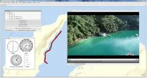
Target Location – The location on a map where the camera is pointed. If implemented, Target Location will show up on a map as the point where the center of the camera meets the ground. Target location may also be referred to as Center Location and Camera Center.
Camera Footprint – The area on a map that corresponds to the camera’s viewfinder. This box (usually a trapezoid due to perspective) is the four corners of a camera view mapped out to an area.
Camera Overlay – Similar to Camera Footprint, except the camera video itself is overlaid onto the footprint.
These features have applications in aerial inspections, search and rescue, law enforcement, broadcast and many more. Today MISB Data is commonly found with high-end gimbals and military equipment, and is now making its way toward the rest of the GIS market.
KLV (Key, Length, Value)
Key Length Value is not only used for MISB encoding, but in many other areas of computer science.
KLV stands for Key, Length, Value, and is a compact method of storing binary data.
Key = The data identifier. Identifies what type of data is stored that is used with the lookup table.
Length = Length of the value. Identifies the length of the data in bytes.
Value = Value of the data. The value may have its own algorithm to generate it’s storage.
For example, KLV can be (HEX):
21 08 00000064
This described the key with hex value 21
A length of 08 (8 characters or bytes)
And a Hex value of 64
Due to the length of the value being defined, multiple KLVs can be concatenated together. For example:
19080000017220040011210800000064
The keys would then be defined in the spec itself:
(Note, these values are made up to demonstrate how it works)
Key 19 = Altitude
Key 20 = Slant Angle
Key 21 = Longitude
This hex string contains 3 Key->Value pairs, with indexes 19 of length 8, 20 of length 4, and 21 of length 8. The total byte size is 32 bytes, giving up human readability found in a format like XML, but compacting data into a very small size suitable for a low-bitrate stream. Dozens of geospatial KLV pairs can be added with minimal increase of the total bitrate of the video stream.
There are other details to how KLV works with MISB (such as packet KLV, timestamps and checksums) however this is the basic idea behind it.
The Container
KLV data can be stored in many multimedia containers, one of the most popular being .TS (MPEG2 Transport Stream). The container used may depend on the desired video or audio codecs, streaming capability, and compatibility.
A container is simply a file object that contains one or more streams. For example, .AVI, .MP4, .TS, .MOV and .MKV are all examples of various video containers. One of the most popular for MISB data is .TS.
Inside a typical .TS container are one or more streams – most commonly, an Audio and a Video. They can also contain a KLV Data stream:
.TS Container
{ Video Stream (H.264)
{ Audio Stream (AAC)
{ Data Stream (KLV)
As the Transport Stream is read, all three streams are decompressed to be interpreted and displayed as Full Motion Video with KLV Metadata. With MISB 0609, this KLV data contains important geospatial data that can be used to calculate how to draw advanced features such as GPS coordinates, target location, camera footprint, etc.
Equipment
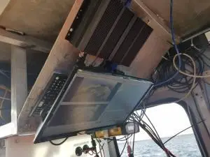
In order to record MISB-enabled video, you must have hardware that can provide the desired parameters. For example, your hardware might need to provide a combination of a laser rangefinder, slant range, or altitude in order to determine target location. Some hardware may provide target location as GPS coordinates directly, others may give you the data and it is up to you to do the math.
How the hardware makes the data available may also vary. Some may give you a KLV stream within the container, others may hide the data in the raw video bitstream. Our geoDVR supports MISB FMV recording with compatible gyro-stabilized gimbal cameras.
Equipment
In order to record MISB-enabled video, you must have hardware that can provide the desired parameters. For example, your hardware might need to provide a combination of a laser rangefinder, slant range, or altitude in order to determine target location. Some hardware may provide target location as GPS coordinates directly, others may give you the data and it is up to you to do the math.
How the hardware makes the data available may also vary. Some may give you a KLV stream within the container, others may hide the data in the raw video bitstream. Our geoDVR supports MISB FMV recording with compatible gyro-stabilized gimbal cameras.
Software
In order to play back the video and use features such as Target Location or Camera Footprint, the mapping software must support playback and interpretation of KLV data. The following Remote GeoSystems software options will allow you to playback video with MISB FMV & KLV spec metadata embedded: